|
The Treaty of Washington: Settlement Begins
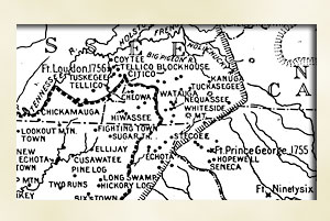
In 1819, the Cherokees signed the Treaty of Washington ceding
their lands as far west as the Nantahala ridge. Commissioners
Jesse Franklin and James Meabin were faced with the task of organizing
the new territory. They appointed Captain Robert Love to lead
the Survey party that mapped the land in late spring of 1820.
This enabled the first land sale to take place on September 20,
1820. Land settlement proceeded rapidly.
The work began with the division of the huge area into 18 districts.
Each was assigned to one of five or six survey crews for mapping.
The districts were further divided into tracts or sections, which
were offered to the public through land grants.
Each section offered for sale contained 50 to 300 acres. Each
included some good farm land and timber land. The survey party
produced a huge map, one copy of which was posted in the Haywood
County courthouse prior to the first land sale. The sale began
Sept. 20, 1820 and continued for several weeks. Other sales were
held in Franklin in 1822 and 1823.
The survey party chose the site of Franklin, which was destined
to become the county seat. The town site occupied 400 acres in
sections 24 and 32 of district 16. It was named for Commissioner
Jesse Franklin, a prominent statesman who became governor of North
Carolina in 1820.
Because of high demand for land, prices were set to bring in a
good profit. No land could be sold for less than 50 cents per
acre. Grade 1, the best, sold for $4 per acre; grade 2 for $2
and grade 3 for $1. Buyers could pay one-eighth down and the rest
in four annual payments, with a discount offered for early payment.
Grants were to be issued after the state received the full purchase
price.
|
|